
The Ancient History of Thistle Cove, Cultural Connections, and the Search for the Mountaineer Shipwr
- Dec 9, 2019
- 5 min read

Join us on an expedition to uncover the cultural history, marine ecology, and maritime history of Thistle Cove, Cape Le Grand National Park, Western Australia.
December, 2020


Join our team of Traditional Owners, maritime archaeologists, and professional surveyors to embark on a collaborative expedition to Thistle Cove – a place of remarkable ancient connection, biodiversity, and maritime history.
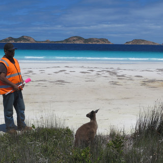
Thistle Cove area is known culturally as Mandoowernup (the place of where the sun shines on the dead man) – a place of immense cultural significance to the Traditional Owners. Cultural mapping work here has documented hundreds of cultural places, features and archaeological sites, that collectively, document aspects of the integrated cultural landscape. Thistle Cove itself contains many archaeological sites, and we know that the Traditional Owners observed the The Mountaineer (1835) shipwreck survivors over those ten days that they were stranded on the beach.
The Mountaineer was a 23-ton cutter involved in sealing and trading with sealers in Bass Strait, Kangaroo Island and Spencer Gulf in South Australia. In January 1835 the Mountaineer was on a return voyage from Albany, Western Australia, when it was wrecked while anchored during a strong gale at Thistle Cove, Cape Le Grand. All the crew and passengers survived, and after spending ten days on the beach, made their way to Middle Island, as the closest known settlement. This island was the base operations for the infamous American sealer - Jack Anderson.
The Mountaineer is a great story about cultural contact between Europeans and Nyungar People – and this event represents the first time Europeans trod that part of the coast between Cape Arid and Albany. The court documents of the time related to the indiscretions of Jack Anderson are the only source of information about activities in the Archipelago of the Recherche at that time. Here, our team will explore the incredible connection and continuity between deep, ancient history, the contact period and the present day – with a collaborative study of Thistle Cove.


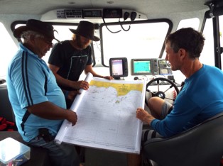


The project will involve 5 main stages:
Stage 1. Cultural Mapping
Stage 1 is a full cultural survey and cultural mapping project with Doc and the representative from each of the six main Traditional Owners of the region. This work will document the cultural connections, traditional ecological knowledge, and map and record the cultural features of Thistle Cove. Under cultural supervision, test archaeological excavations will take place in targeted areas to explore the sub-surface potential of cultural deposits, and provide a chronological context to the human history of connection.
In searching for the wreck of The Mountaineer, by our specialized team, we will examine the interplay of the cultural and historical stories of place – where the Cove itself was a ‘contact event’ and survivor camp location. We will also explore how this story also relates to the subsequent survivor trek of shipwreck survivors (Newell and Manning) between Cape Arid and Albany along the South Coast, also with the assistance of Nyungar People. Juxtaposing these kind of early European contact events and ‘discoveries’ with long-term knowledge and understanding of the landscape by Traditional Owners, is a great way to present the continuous and interwoven histories of the area.
Stage 2: Coastal Geomorphology Study
The team will map and document the coastal geomorphology of this landscape, to understand the way the beach and headland was formed – related to rising seas associated with the end of the last Ice Age.
This component will also involve luminescence dating of the high sand dunes, that will help us understand when the present-day coastline was formed, and the associated coastal ecosystem.
Stage 3: Sea-floor mapping
Our team will then carry out a full-scale survey of Thistle Cove, using a combination of an Unmanned Aerial Vehicle (UAV) and survey grade depth sounder. With our UAV, we will capture a 3D model of the topography to within 50mm. Additional, this platform will also give an up to date aerial image of the survey area.
The UAV will also be coupled with an infrared red thermal imaging camera – and this imagery can also be combined and overlayed on a map of the survey area. At the same time, we will perform a precise bathymetric survey with a mounted survey grade depth sounder and a survey grade GPS – to deliver an underwater topographic model with accuracies around 50mm. Both technologies can be paired to create a complete 3D model of any island and it's surrounding under water topography.


Stage 4: Shipwreck Survey
With the date from Stage 3, the team will isolate anomalies that may reflect possible shipwreck features. An ROV will be deployed at these locations, from our research vessel, Payne’s Find. The ROV allows our team to further investigate any area safely without putting anybody in the line of fire in this well-known Great White Shark territory. The ROV can be used for underwater inspections and analysis of any marine environment.
A beach/ inter-tidal survey strategy will also take place, as the ship was blown ashore in a storm, was a relatively small vessel (dimensions max. length 10.72 x max. breadth 3.91 x draft 1.42m) and all the passengers survived – so it must be on the beach or very close to. It was constructed out of Tasmanian timber and therefore there is not predicted to be much iron on the vessel. A similar wooden sealing vessel was blown ashore at Tagon Bay opposite Middle Island in a storm and that was reported in the 1980s as having been exposed in the intertidal zone, then quickly reburied under 6 feet of sand - so would predict similar depth of burial for The Mountaineer.
This will then involve a magnetometer survey in the bay, coupled with a beach-based magnetic beach survey. We are up against it here, as The Mountaineer was a wooden cutter and may not have much iron on it – and there is historical information that notes that pirate Jack Anderson salvaged the anchor, back in 1835. However, the combination of our highly experienced dive team, and with the technologies involved in sea-floor and habitat mapping, we are confident in narrowing down the exact location of the infamous shipwreck.
Stage 5: Underwater Archaeology
Our dive team and crew from Payne’s Find, will then capture the locations with video and cameras, and carry out a full-scale dive survey plan. This will involve live feed cameras back to the Traditional Owners and archaeologists in the research vessel. The captured data will have presented as a documentary on all stages of the expedition, the documentation of the marine ecology, and, as hoped, the first documentation of this shipwreck in and marine ecology of this bay in 183 years!

The Core Team
Cultural Mapping, led by Doc Reynolds and Traditional Owners
Landscape Archaeology, Applied Archaeology International
Maritime History, research led by Dr. Ross Anderson, Maritime Archaeology Dept., WA Museum
Sea-floor Mapping, Drone survey and ROV Operator, Stu Buckett.
Audio and Visual, ABOVE Imagery, Andy McGregor
To Get Involved
A limited number of internship/field assistant placements are available for this expedition. There is a registration fee that covers all instruction, accommodations and food. Opportunities to link your participation to university credit and/or professional development.
For more information, please contact David Guilfoyle: dg@appliedarchaeologyinternational.com


Comments